Navionics+ kart som er kompatibel med de fleste plottere unntatt Garmin.
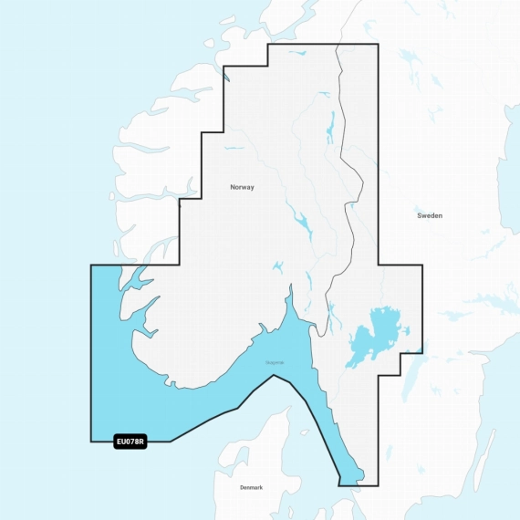
Detaljert dekning av den norske og svenske kysten fra Haugesund til Halmstad (i Sverige) inkludert Boknafjorden, Oslofjorden, Skagerrak, Mjøsa, Bandak, Kviteseidvatnet, Flåvatn, Norsjø, Heddalsvatnet, Telemarkskanalen og havnebyene Stavanger, Kristiansand og Oslo (i Norge) og Göteborg (i Sverige).
Get the world’s No. 1 choice in marine mapping1 — with the best, most up-to-date Navionics®+ cartography on your compatible chartplotter2. For offshore or inland waters, this all-in-one solution offers detail-rich integrated mapping of coastal waters, lakes, rivers and more. Get SonarChart™ 1’ (0.5 meter) HD bathymetry maps, advanced features3 such as dock-to-dock route guidance technology4, live mapping and Plotter Sync to provide wireless access to daily updates. The Navionics® Chart Installer software also ensures the freshest chart data every time out. Navionics route guidance solutions give you a suggested path to follow through channels, inlets, marina entrances and more. Multiple shading options aid in shallow water navigation and make it easy to highlight a target depth range for the best fishing spots.
Kompatible enheter:
https://www.navionics.com/media/wysiwyg/docs/Compatibility_Guides/GPS_Plotter_Cards_Compatibility_Guide.pdf
Dekker disse innsjøene hvis det er innenfor kartdekningen (PDF).

Kartbrikke, Navionics+ Oslo, Skagerrak & Haugesund, NAEU078R - microSD™/SD™ card ( ikke Garmin)
Passer ikke til Garmin.
MicroSD/SD kort.
MicroSD/SD kort.
Varenr: 010-C1323-30
1.690,-
Velg produktalternativer
Velg komponenter
1.690,-
Navionics+ kart som er kompatibel med de fleste plottere unntatt Garmin.
Detaljert dekning av den norske og svenske kysten fra Haugesund til Halmstad (i Sverige) inkludert Boknafjorden, Oslofjorden, Skagerrak, Mjøsa, Bandak, Kviteseidvatnet, Flåvatn, Norsjø, Heddalsvatnet, Telemarkskanalen og havnebyene Stavanger, Kristiansand og Oslo (i Norge) og Göteborg (i Sverige).
Get the world’s No. 1 choice in marine mapping1 — with the best, most up-to-date Navionics®+ cartography on your compatible chartplotter2. For offshore or inland waters, this all-in-one solution offers detail-rich integrated mapping of coastal waters, lakes, rivers and more. Get SonarChart™ 1’ (0.5 meter) HD bathymetry maps, advanced features3 such as dock-to-dock route guidance technology4, live mapping and Plotter Sync to provide wireless access to daily updates. The Navionics® Chart Installer software also ensures the freshest chart data every time out. Navionics route guidance solutions give you a suggested path to follow through channels, inlets, marina entrances and more. Multiple shading options aid in shallow water navigation and make it easy to highlight a target depth range for the best fishing spots.
Kompatible enheter:
https://www.navionics.com/media/wysiwyg/docs/Compatibility_Guides/GPS_Plotter_Cards_Compatibility_Guide.pdf
Dekker disse innsjøene hvis det er innenfor kartdekningen (PDF).

1.690,-